
Monday, June 1, 2026, Harpole Mesa, Utah.
- David Barbeau
- Jun 6
- 6 min read

[Please note that this post is a bit late from when it was written as we try to keep up with all our responsibilities. The next post is forthcoming during our drive home which begins tomorrow, June 7.]
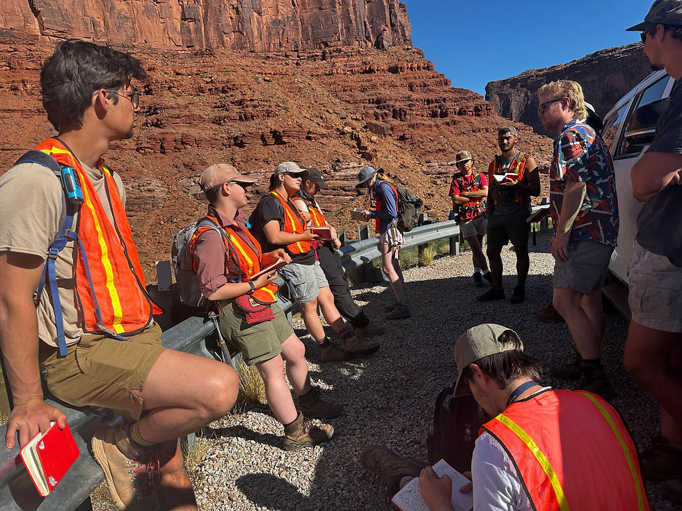
All is well at Geology Field Camp. In contrast to the typical heat of the Moab / Salt/ Castle / Professor valleys below us, we are enjoying 15° cooler temperatures up here on the shoulder of the La Sal mountains at our final ‘wild’ camp of the 2026 iteration of the USC McCausland College of Arts & Sciences School of the Earth, Ocean, and Environment (USCMCASSEOE?) Geology Field Camp. It’s a durn good thing too, as the lower elevations are experiencing upper 90s (F) temperatures, which although free of the humidity that complicates summer outdoor work in South Carolina, seems nearly as challenging — escaping the sun is nearly impossible during the middle part of the day. Shade is almost nowhere to be found, and as Howe Gelb has said of the southwest: it is a punishing sun. It is such a relief to retreat to the shade and cooler temperatures of the mountains in the afternoons and evening after days of hard work down below.
Students are working on a ~8 km thick regional stratigraphic column for the northern Colorado Plateau, covering strata from the upper Carboniferous Paradox Formation to the Upper Cretaceous rocks of the Book Cliffs to our north. Towards those ends, after a stop at the spectacular exposures of the undivided Pennsylvanian-Permian Cutler Formation at Fisher Towers, today we moseyed up the picturesque (and white-knuckle-driving) Onion Creek Canyon to examine rare surface exposures of a salt diapir in the proximal part of the salt anticline province of the late Paleozoic Paradox foreland basin. Paired with their mapping of the San Rafael Swell over the past weekend (more on that in a moment) and examination of the Jurassic-Cretaceous section west of the notoriously windy (but I digress, ahem) Salt Valley northwest of Moab tomorrow, the students will have recorded and interpreted the late Paleozoic-Mesozoic history of sediment supply and accommodation in the western interior of the United States, which will help with their interpretation of the regional (tectonic, mostly) geology of the greater North American Cordillera (and its predecessors) at the latitude of ~39°N that constitutes their final project, due in less than a week.

To catch up to today: when last I wrote we were undertaking a mapping project of the frontal parts of the thin-skinned Sevier fold-thrust belt in the Canyon Range of central Utah. It is a monster project that when pursued by individual mapping partners requires four days of mapping to cover the 10 square km of the map area. [Moreover, the terrain is steep with numerous side canyons, most of which have become choked with scrub oak after the Canal Fire decimated the range’s pinyon-juniper forest in 2020. It is daunting to say the least.]
Our current integrative regional approach to field camp (i.e., characteristic stands of trees in a large and diverse geologic forest) does not enable the dedication of so much time to a single project, so last year we did a one-day group transect, in which each student completed a (guided) strip map of Oak Creek Canyon and its environs. Although it went well, and students came away with the key observations from the Sevier belt, it felt a bit underdone, and too top-down. This year we added a day and a half of field work, and subdivided the map area into thirds, allowing each mapping group to get close experience with the involved rocks and contacts, and to contribute critical information to a group map that each student then used to craft a cross-section. A group hike to the crest of the range on the following day cemented observations made by each group and highlighted some of the key aspects of fold-thrust belts, and how their kinematics can be reconstructed from synorogenic sediments. We may have found the Middle Way.

Upon completing our Canyon Range project, we moved to the drier, hotter and lower elevations of the San Rafael Swell on the northwestern edge of the Colorado Plateau, where climate and geology have conspired to reveal an exceptional and classic Plateau structure. Last year, very high temperatures and an uncooperative road nixed our first attempt at mapping the Swell, but allowed some reconnaissance for a return attempt this year. Pursuing a canyon north of our foiled attempt last year, we were able to get within a kilometer or so of our map area in the San Rafael Reef Wilderness Area and establish camp along the Swell’s fringe.
We were greeted by USC geology alum and former field camp teaching assistant Marissa Wright fresh from completing a stint as a geological interpreter on a guided descent of the Yampa River — spirits were high in anticipation of her visit and chat with our students about her experience in the energy industry, the pursuit of a professional MS degree in energy geosciences, and in wilderness geology. But within minutes of getting personal tents set up, the second Field Camp Haboob of 2026 rolled in, threatening all of our tents, collapsing some of them, and harkening back to the traumatic sandstorm outside Bishop that ran us out of the Benton Range and to the Motel 6. Alas despite its gallant efforts, the Swell Haboob was unable to deter us from our goal. After an hour of holding down tents as gale after gale blasted us and our gear with sand and silt, it abated enough for Marissa to host her chat while the Staff hustled to prepare potato pesto penne in anticipation of the next shoe dropping. Although two bags of prized pine nuts brought all the way from the Forest Acres Trader Joe’s — and toasted expertly by Emily Baumann — were lost to an unexpected post-Haboob gust, we were grateful to survive the storm and to retire to our (dusty) tents to face another day.

And wow, were we rewarded. With what students and staff have widely recognized as the best map area and campsite of the trip, the Swell delivered: a reasonably mild but spectacular transect of the structure whose exceptional exposure enabled comparatively easy mapping for students who cut their teeth in much less well exposed and more complicated geology further west.
[Another wrinkle in our current approach — geology becomes less complicated in the eastern part of our transect, making an east to west transect in some ways the most pedagogically sound. However, because of time and/or money we can’t afford to start in Denver and end in Sacramento without additional airfare or a long drive all the way across the country to conclude our trip, when proverbial gas tanks are spent. But I digress].
An unanticipated bonus of this year’s Swell map project is that students became familiar with Colorado plateau stratigraphy from basic principles, direct observation and a phenomenon-first approach, rather than the top-down approach we usually must take in introducing students to the plateau’s units. This seemed to pay off not only in their learning of the stratigraphy and the environments of deposition that created them, but in connecting them more deeply and directly with the geology they will spend the next week studying, documenting and interpreting.
The students and (especially) my staff have continued to work wonders in keeping this vagabonding educational meshugas chugging along. Sometimes I forget how much goes on outside the geology itself in order for us to explore it and learn critical techniques of geologic analysis (and other forms of systematic critical thinking). It is so much more work than the classroom, but during and in hindsight, it seems beyond worth it (and very well might be — with Katherine Ryker’s mentoring, Lance has a paper in review at the Journal of Geoscience Education documenting the gains of our approach — so much so that he has been invited to give a keynote talk in the upcoming Geological Society of America meeting this Fall in Denver.)
Onward.


Comments